Gros Morne National Park is definitely worth the trip to
Newfoundland—lots of hiking trails, lakes and nature to admire.
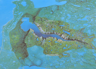
This section discusses inland fjords (on the map referred to as ‘etangs’), particularly Western Brook Pond, the coastal lowlands and the Tablelands. The map is published by Parks Canada and is available in the visitor centers.
The Inland Fjords
One of its great physical features is the Western Brook Pond which
really is a lake. It also is an inland fjord, a geographic feature first carved
out by a river and then by an alpine glacier. The graph below shows how a
stream-cut valley differs from a valley cut by an alpine glacier—it is usually
much deeper and broader on the sides with steeper walls.
 |
A. Sketch of stream-cut valley;
B. Sketch of calley after modification by glaciation
Source: Rocky Mountain. The Geologic Story of the Rocky Mountain National Park Colorado. Available at http://www.nps.gov/parkhistory/online_books/romo/lee/lee/sec1.htm
|
A fjord comes into existence if the alpine
glacier ends in an ocean and then calves off at its end (see the sketch of the
fjord). As the glacier retreats or melts it leaves a depression behind that
will fill up with sea and river water. As shown on the sketch the glacier
produces at its mouth where it calves a heap of unsorted rock material, its end
moraine, which is characteristic of fjords. This sill is usually submerged as
well.
 |
Source: Geologic Genesis of a
Fjord. Wikipedia accessed at https://en.wikipedia.org/wiki/Fjord#/media/File:Fjord_genesis.png
|
Western Brook Pond came into existence after all the glacial ice melted.
With the disappearance of the ice enormous weight was taken off the land, the
land itself rose higher above sea level, it rebounded. It rebounded so much
that the sill would eventually emerge above water creating a barrier to the
sea. Western Brook Pond thus became a long, narrow lake which is commonly
referred to as an inland fjord. Its only outlet to the sea is Western Brook.
 |
| The Drainage Basin of Western Brook Pond Source: Parks Canada, Western Brook Pond. |
 |
| Western Brook. |
Because the pond has only one outlet it takes the water about 15 years
to be completely exchanged, a fact that makes the pond quite susceptible to
pollution. In recent years, since the 1970’s, the use of the lake has increased
via tour boating.
 |
| View onto Western Brook Pond from a western vantage point |
Western Brook Pond contains some of the purest water in the world which
is due to its limited drainage basin of the surrounding mountains, the sparse
vegetation on those mountains and its general remote location. In addition,
some of the brooks drain over limestone which cancels out the acidic drainage
from upland swamplands thus giving the water a neutral pH value. The lake
itself is classified as ultra
oligotrophic, that is, it contains very few nutrients, a consequence of the
fact that few plants can find root on its steep sides and bottom. Even though
the lake is very clear and light can penetrate to about 10 m of depth, its
depth and relative coldness (in summer it never gets any warmer than 5 °C
(about 41 °F) hinder plant growth which results in low diversity of lifeforms
within the lake.
The Geology of the Region
This photo shows the physical landscape into which the pond is carved.
It consists of the Long Range Mountains in the background which are the result
of a fault and the flat coastal lowlands before it (compare photo). The rock itself is Proterozoic granite which
metamorphosed into gneiss during the Grenville orogeny
 |
| Source: Parks Canada, Western Brook Pond |
 In some cases, the
peaks of the highest mountains protruded above the ice sheets and were not
subject to the erosion of the glaciers. These glacial features are known as nunataks.
The Flat Coastal Lowland
Since
the area displays great geologic diversity showcasing rocks from many different
time scales and of various origins it should not come as a surprise that the existing
flora is also rather diverse. All in all, according the UNESCO web site here, the area distinguishes
between 36 different vegetation types and communities. Below are some photos of plants that seemed to
be indicator plants in the coastal lowlands, often in the more swampy areas.
 |
| A "meat-eating" beauty |
The Tablelands
 |
| The Tablelands. Photo taken at Norris Point. |
Even
an inexperienced eye surveying the physical landscape portrayed above will notice
the difference between the mountains in the background and the surrounding
mountains. The lack of vegetation is rather noticeable, even from the distance.
This
region is one of the reasons why the Gros Morne National Park area became a
UNESCO Heritage Site since it illustrates some of the processes connected to
the movements of earth’s plates, to the theory of plate tectonics.


No comments:
Post a Comment