Sunday, June 21, 2015

8-The Beothuk—Newfoundland’s Aboriginal People

 Beothuk Interpretation Center, 
Boyd’s Cove, Newfoundland.
Little is known about the original inhabitants of Newfoundland, the Beothuk (pronounced ‘beothik’). The findings at the Boyd’s Cove archaeological site showcase a culture adapting to change. In general, the Beothuk kept to themselves having been quite disillusioned by the settlers who allegedly attacked them mistaking a dance of joy for warfare preparation. Ever since this incident they were perceived as dangerous and many battles were fought. The last of the Beothuk, a woman named Shanawdithit, died in St. John’s of TB in 1829.


Also, unlike other indigenous groups elsewhere in North America, the Beothuks received whatever they needed without engaging in trade; i.e. without having to modify their way of life. This is due to the fact that Newfoundland’s colonialists really did not settle permanently for the duration of about 70 years between 1650-1720, rather they arrived in the spring and went back to Europe in the fall with all their cod and sealskins. Once the colonists went back to Europe, the Beothuk would arrive in their fishing stations and take metal products and mold them to their needs.


In particular, they were interested in nails that were left behind in the structures and/or discarded items. These nails were relatively soft so the Beothuk would pound on them changing their shape. A portion of the nail would be used for scraping; the more important portion of the nail, however, was used as arrow heads as this was a great improvement over their less effective and durable stone projectile points.
Beothuk Interpretation Center, Boyd’s Cove, Newfoundland.
It is believed that the Beothuk were related to the Algonkian speaking native peoples of southern Quebec and Labrador. They may have descended from the Maritime Archaic Indians of southern Labrador whose sites were dated to 7,500 years ago. Some of them may have come to the island of Newfoundland around the year 1,000.

The archeological site at Boyd’s Cove discovered by an archeologist affiliated with St. John’s university in 1982 yielded some Beothuk tools and other signs of early settlement from over 1000 years ago but the most prominent findings  date to the time between 1650 to 1720. It allows a glimpse into their lifestyle before the arrival of the European settlers and is at this point the most important source of information.
Beothuk Interpretation Center, Boyd’s Cove, Newfoundland.
Most likely the site was chosen because it provided safe and shallow sites for canoes as it is protected by a maze of channels and islands. The fresh water source,  a stream that teems with small silvery fish once a year—the annual smelt run—might have been a factor. In addition, a natural embankment that put the actual settlement site way above sea level provided protection from the sea but also from possible attackers. The embankment  itself is a moraine, an assortment of gravel, rock and bolders left behind by glaciers. Water drains easily into/through such a foundation leaving the surface relatively dry.
View from the Beothuk settlement site down to the bay.

View from the beach to the settlement embankment. 

View from the beach to the settlement embankment. 
The Boyd’s Cove Beothuk built their houses by digging into the ground and then erecting wigwams in them. Bark, animal skins and even sail cloth might have been used for the roof.
Source: Beothuk Interpreation Center, Boyd’s Cove, Newfoundland.
The interior of the wigwam might have looked like this:
Source: Beothuk Interpreation Center, Boyd’s Cove, Newfoundland.
Caribou were vital for the survival of the Beothuk as they provided food, clothing and sewing materials (sinew).  Since caribou usually travel in large herds the Beothuk  developed an efficient technique of hunting: they built a large fence along areas where they were to arrive driving the animals into water. From there it was easy to get to the helpless animals.

Archaeologists were excited to find a larger-sized plot which might have served as mokoshan site, a site where a feast was celebrated honoring the caribou spirit as it was done in Northern Labrador. Here the mokoshan was usually celebrated in a special oval structure which was also found on the Boyd’s Cave site.

Another piece of evidence of the Beothuk’s spirituality and also their geographic origins is their use of red ochre as a body paint and on burial grounds. This might have had symbolic meaning linking blood with life and death.

In addition, the Ramah chert was discovered at the site—the rock’s natural origin is in Northern Labrador. A carving of maybe a bear discovered might have some spiritual importance.

Sources: 
1) Beothuk Interpretation Center, Boyd's Cove, Newfoundland.
2) The Beothuk, Heritage Newfoundland and Labrador, accessed at   http://www.heritage.nf.ca/articles/aboriginal/beothuk.php

Saturday, June 20, 2015

9-The Vikings – The First European Discoverers

Starting in the 9th century the Norse from Norway and other Scandinavian countries migrated westward, first to Iceland then to Greenland and on to Labrador and the Newfoundland. Their reasons for their westward expansion are not really known but it is assumed to have been a mix of overpopulation and the wish to hold on to old traditions. They colonized Iceland within 14 years of the island’s discovery in 860 and by 930 all of Iceland was settled. Iceland might have felt the pressures of overpopulation; in addition a major famine occurred in 975 making a westwards migration a necessity. Greenland was discovered in 982 and experienced its first settlement in 985. The map below shows that it might have taken the Norse about 7 days to sail from Iceland’s southwestern reaches to Greenland’s southwestern settlement. This would be under ideal conditions and with ideal ships. Greenland had two Norse colonies; one in the south and one further northwest. It has been estimated that the settlement in the south reached between 3,000 to 4,5000 people, fewer people lived further north.

Source: Interpretation Center L'Anse Aux Meadows, Newfoundland, CA.
According to the Norse sagas, a Norse businessman first set eyes on Labrador and/or Newfoundland around 1,000 AD. His ship from Iceland to Greenland had come off course due to bad weather and on correcting the ship’s course he noted the heavily forested coastline and glaciated mountains. 
Source: Interpretation Center L'Anse Aux Meadows, Newfoundland, CA.

The two globes above show the time it might have taken the Vikings to get from Iceland to Greenland and then from Greenland to Newfoundland under the best possible conditions. We were told, that the trip from Greenland to Newfoundland was sailed by some enterprising adventurers in a replica of the Viking sea-worthy boat, the "knarrs" (not the longboats), and it took them 85 days. These adventurers, however, might have lacked sailing those skills that the Vikings possessed.

Whatever the reasons, the merchant and other Greenlanders weren’t really interested in the discovery of new land, they were more into trade and survival in Greenland. Here stock-raising, i.e. sheep and goats, was the primary agricultural economy since crops had a hard time growing.  So, it took another decade or so for the son of Erik the Red to sail south from Greenland—naming today’s Buffin islands "Helluland",  Labrador "Markland" and possibly, but  not definitely, Newfoundland "Vinland" because there were so many wild grapes growing. His quest was not so much for new land but for support of the existing Greenland and Icelandic settlements since these areas by that time were suffering environmental degradation due to continuous tree felling and livestock grazing. Their ships, the knarrs, were well equipped for cargo thus it is feasible that the Newfoundland coast served as support for the Greenland settlements.

The Viking settlement that has been partially excavated in L'Anse Aux Meadows provides clues as to what the Vikings were doing there. Apparently this was a seasonal settlement which was most likely  used as base camp for ship repair to get to other, more southern areas along the coast for the duration of three years.. Interactions and skirmishes with the Beothuk during this time appeared to have occurred  along the coast, probably a reason why the Vikings didn't colonize the area. At L'Anse Aux Meadows there were clues that the Viking settlement was very close to a Beothuk settlement, a settlement that might have been occupied off and on for about 6,000 years.


Replica of partially excavated Viking settlement site in L'Anse Aux Meadows.
The original site was on the brown earth area right outside the fence in the foreground.
--Sketch of the village envisioned by archeologists--


Friday, June 19, 2015

10-The Saltbox House


Renovated saltbox house, fourth generation 
So, this year we are spending 8 days in a saltbox house in Twillingate, Newfoundland. The regional architecture has been well documented in the movie “The Shipping News” where one of those saltbox houses had to be anchored to survive heavy storms. Eventually the anchor fails to keep the house in place…


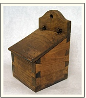
Historical saltbox
Why is the house called a ‘saltbox’? Because it looks a bit like a saltbox (see photo). Salt was very important to colonial Americans for food preservation. In order for salt to not clump up it needed to be kept dry and thus was put into those saltboxes which, in turn, were hung close to the hearth of the house so it would remain dry. (Source: Historic House Blog at http://historichouseblog.com/2009/01/11/why-do-they-call-it-a-salt-box/) 


Most Newfoundland houses are built of wood which is a function of the environment since lumber was and is easily available and could be built quickly. Brick and stone houses required money, skilled work plus a quarry for the stone. Since most wooden houses don’t hold up well against harsh environmental conditions and it is relatively easy to build a new house, it is rare to see a 100-year old house still standing. For that reason it is rather difficult for a cultural geographer to come up with a house typology that might work across the board—but certain house elements—particularly the floor plan--have proven to be relatively persistent.

Much of the information on these houses is derived from Mannion, ed. The Peopling of Newfoundland: essays in historical geography, Social and Economic Papers series; No. 8 (St. John's, NL: Institute of Social and Economic Research, Memorial University of Newfoundland,1977). It is interesting to note that the saltbox houses of Newfoundland seem to have evolved about 100 years later than the identical houses in New England. Here as well as there the long, low pitched roof was to partially deflect the effects of snow and rain.

Mannion, ed. The Peopling of Newfoundland: essays in historical geography, Social and Economic Papers series; No. 8 (St. John's, NL: Institute of Social and Economic Research, Memorial University of Newfoundland,1977)

The first generation house was a single-story house with a loft and a peaked roof. Children generally slept in the loft which often had one or two gable windows. The second generation is a saltbox house with a full second story. The front door was only used for formal occasions. Usually the house was raised by one floor at the time when the roof needed repairs or when two generations lived under the same roof.

The third generation evolved from the saltbox house showing a full two-story structure and a flat-roofed two-story addition, an economical increase of living space. The junction of the flat roof and the peaked roof was difficult to keep watertight with shingles, so flexible felt was used on the flat roof and shingles on the peaked roof. The fourth-generation house eliminated the problems of the third-generation by using a more steeply pitched roof. Basically, the fourth-generation house was re-roofed; size-wise it was somewhat smaller. Inside, a central hall was introduced.


The study the results of which  I used as guidance on saltbox architecture was carried out in the Trinity--Bonavista area some 40 years ago but one can conclude that most of the coastal areas will showcase similar architecture (the saltbox house itself is derived from English cottages) as long as the settlers were predominantly English/Irish. In Twillingate one can see some of the old house structures but most houses have been renovated; at the very least they received some new, fresh siding. Thus it is difficult to find original first through fourth generation saltbox-style houses but in many cases the style was not entirely discarded, some of the style development remains visible. I am posting some photos here where elements of first to fourth generation houses are visible.
Elements of second generation house visible even
though there is an extra story.

Elements of the third generation clearly visible.

Elements of the third generation visible and added on.